
|
|
||||||||
|
|
Silk Road |
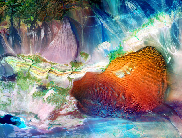 The ancient trade route known as the Silk Road passed through this area of the Xinjiang Uyghur Autonomous Region in northwestern China. This route brought luxurious trade goods, in particular much prized silk, from China to markets in the Middle East. It served as an important connection between the cultures of East and West, leaving its mark on the great civilizations of our world. Travelers along this route included Genghis Khan and Kublai Khan who conquered and controlled a large portion of central and east asia. Although Marco Polo is known to have traveled the Silk Road, his path followed the southern branch around the Taklimakan Desert, rather than the northern branch that passes through this image. Eventually, the development of sea routes between China and the Middle East led to the demise of the Silk Road and its prosperity faded into the desert sands. Included in this image are Aydingkol Lake at the bottom of the Turpan Depression (second lowest elevation in the world, only the Dead Sea is lower) seen at the lower left edge; the Flaming Mountains, running left to right across the middle of the image, famous for their glowing red rocks in the afternoon sun; the ancient city of Gaochang, initially constructed in the first century, B.C.E.; the Bizaklik Thousand-Buddha Caves which provide a rich depiction of Buddhist influence on this part of the world with its caves and murals; and the ancient Karez system of underground channels to bring much needed water to this arid region from the Tian Shan (Heavenly Mountains). The prominent manta-shaped dune sea is the Shanshan Desert, formed by sand blown into the Turpan Depression. This image covers an area of approximately 70x53 miles. A full-resolution crop of the image file is available here that shows the detail present in this print.
|
| Copyright 2011 - Remote Sensing Art and Photographs by Larry P. Ammann, Digital Artist and Photographer. All Rights Reserved. No image or photograph may be reproduced without the artist's express written permission. |